Trails / Charlevoix to Traverse City
In Progress
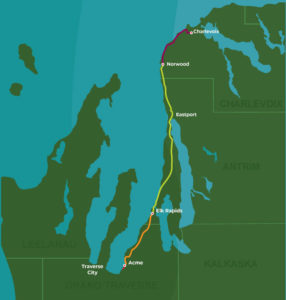
Nakwema — Ojibwe for “where paths connect” — spans over 45 miles joining Charlevoix and Traverse City, in between and beyond.
Map & Directions
The Nakwema Trailway follows long-ago established routes through the waters and woods of northwest Lower Michigan.
The interactive route map, segment status, and project updates are maintained by the Nakwema Trailway partnership on their site.
About the Trail
The Nakwema (nah-KWAY-mah) Trailway spans over 45 miles, joining Charlevoix and Traverse City — in between and beyond. Nakwema, Ojibwe for “where paths connect,” follows long-ago established routes through the waters and woods of northwest Lower Michigan, allowing active access to the pristine land and waterscapes that have captivated us for centuries.
This landmark trailway in turn connects a 325-mile trail network that spans across the state, creating one of the largest trail systems in the nation. Explore and honor the beautiful land, water, and people connected throughout this corridor. Find your way on the Nakwema Trailway.
To learn more about the trail and project updates, visit nakwematrailway.org.
Get Involved
Trails are built and maintained by volunteers and donors. Join us.